Showing posts with label FoD. Show all posts

𝕸 Government & Law - Medieval

Agisters, Verderers, Medieval Forest of Dean, New Forest ..
Barter & Coinage in Britain 
Evolution of English Law ..
Law and Order in Anglo-Saxon England  ➧
Leges Henrici Primi ..
Magna Carta ..
Marriage Act of 1836 ..                

Agisters, Verderers, Medieval Forest of Dean, New Forest


Agisters, Archaeology, Forests, History, Hunters, Ironworkers, Miners, Verderers, Woodsmen

The Verderers in the Forest of Dean have been in existence since at least 1218 and are charged with protecting the vert and venison (that is, generally, the vegetation and habitat) of the Forest. They are the last remnant of the traditional forest administration – unlike the New Forest, their structure has been unaltered over the centuries – there are still four verderers just as there has been for the past 800 years. The Verderers are elected by the freeholders of Gloucestershire at the Gloucester Court (an ancient procedure in its own right) and serve for life. Over the years, the deer in the Forest of Dean have fluctuated in numbers and species (they were totally absent for about 90 years from 1855) but today a herd of about 400 fallow deer inhabits the Forest. The Verderers now meet quarterly in their courtroom in the Speech House, close to the centre of the Forest.
https://en.wikipedia.org/wiki/Verderer#Forest_of_Dean_Verderers
http://www.deanverderers.org.uk/verderers-history.html
https://en.wikipedia.org/wiki/Reeve_(England)

The Agisters are employees of the Verderers of the New Forest. They are often commoners in their own right, and as such depasture stock themselves, thus giving them an intimate knowledge of the area and the workings of the Forest. The word agist means to take in to graze for payment, and this explains part of their role. The post of Agister is medieval in origin, when they were also known as ‘marksmen’. As officers of the Crown they were required to collect grazing fees from ‘strangers’, those who wished to depasture animals but had no right to do so. New Forest commoners with rights of pasture did not have to pay a fee at that time.

To be an Agister a person must be adept at handling all types of livestock, an excellent rider, and able to work, very often on their own, in the rough and tough conditions found out on the Forest. The hours are long, and they can be called out at any time and in any weather to deal with an emergency. They also have the general public to deal with, and are required to be good ambassadors for the Forest in general, and commoning in particular.

Their work is to assist in the management of commoners’ stock on the Forest, and carry out instructions given to them by the Court of Verderers. Much of their time is spent out on the Forest, often on horseback, observing the conditions of both land and stock. They are on call 24 hours a day, seven days a week to respond to any problem involving the stock on the Forest. In the spring, they collect the ‘marking fee’, which is the payment a commoner has to make for each animal he wishes to turn out onto the Forest. This helps to offset the cost of their employment. They are also required to report to the Verderers any breaches of the Verderers’ byelaws, which could include such things as unbranded or unpaid for animals.

Another important aspect of their work is the monitoring of the welfare of the livestock on the Forest. During the winter and spring the stock will lose some body condition. The Verderers, in conjunction with various welfare organisations, set a condition standard below which the animal must not fall. If it does the Agister will arrange its removal from the Forest back to the owners holding so it can receive supplementary feeding

There are currently five Agisters, one Head Agister, and four colleagues. Each one is responsible for a specific area of the Forest, but many of the tasks they carry out require them to work as a team. Much of the day to day routine will involve contact with both the animals and the people on their ‘patch’ and an Agister will develop an uncanny ability to identify animals and to whom they belong. In the late summer and early autumn the Agisters organise the ‘drifts’ or round-ups of the Forest ponies. At this time the ponies are ‘tail marked’, a certain cut of the hair of the tail of the pony is put in to show the pony has been paid for. Each Agister has his own mark, and this is to signify in which Agisters’ area the owner of the pony lives. Any foals that are to be kept are branded with the owners individual brand, a register of which is held by the Verderers. Commoners may take this opportunity to remove any ponies they want to sell or take in for the winter, and the rest of the ponies are given a good check over before being released back out onto the Forest. The Agisters are called out to deal with all sorts of problems. Animals stuck in bogs, ditches, fences or cattle grids, straying into people’s gardens or onto fenced roads, ponies with colic after eating lawn mowings or other garden refuse, or cows choking on discarded plastic bags. Sadly one of the more common call-outs is to road accidents. Despite speed limits and much publicity there are still a large number of animals being hit and killed on the Forest roads. It is often the Agister’s unpleasant but necessary duty to put the animal out of its suffering, and then inform the owner of their loss.

http://www.verderers.org.uk/Agisters.pdf

Agistment originally referred specifically to the proceeds of pasturage in the king's forests. To agist is, in English law, to take cattle to graze, in exchange for payment.

Agistment originally referred specifically to the proceeds of pasturage in the king's forests in England, but now means either:
1. the contract for taking in and feeding horses or other cattle on pasture land, for the consideration of a periodic payment of money;
2. the profit derived from such pasturing.

Agistment involves a contract of bailment, and the bailee must take reasonable care of the animals entrusted to him; he is responsible for damages and injury which result from ordinary casualties, if it be proved that such might have been prevented by the exercise of great care. There is no lien on the cattle for the price of the agistment unless by express agreement.

Under the Agricultural Holdings Act of 1883, agisted cattle cannot be distrained on for rent if there be other sufficient distress to be found, and if such other distress be not found, and the cattle be distrained, the owner may redeem them on paying the price of their agistment. The tithe of agistment or "tithe of cattle and other produce of grass lands" was formally abolished by the Act of Union in 1707, on a motion submitted with a view to defeat that measure.

In England, Agisters were formerly the officers of the forest empowered to collect the agistment. They have been re-established in the New Forest to carry out the daily duties of administering the forest.

https://en.wikipedia.org/wiki/Agistment
https://www.forestry.gov.uk/forestry/infd-6a4kq7
http://www.verderers.org.uk/court.html
http://www.verderers.org.uk/
https://www.newforestmemories.org.uk/rules/agisters

regard inspection of a forest by regarders with foresters and woodwards, presented to the swanimote court next before and preparatory to an eyre, included vert, eyries, mines and forges, ports, harbours and the wood they shipped, dogs, nets and weapons; swarms of bees, wax and honey were also included in the charges of the swanimote and eyre where regards were enrolled (M 227 (v) and 242 (v)). The king might exempt private land and woods in a forest from regards (M 58 (r) and (v), 196 (r) and (v))

regarder officer responsible for making triennial inspections of forests to discover trespasses (P 205); ministerial rather than judicial officer appointed by royal letters patent under oath, twelve per forest, to hold a regard and enrol all offences discovered for presentation through a swanimote to an eyre. Duties specified in the Charter of the Forest (1217); called lespegend in Canute’s Forest Charter (1016) (M 1(v), 6 (r) and (v) and 191 (r) – 200 (r))

http://info.sjc.ox.ac.uk/forests/glossary.htm
http://www.deanverderers.org.uk/glossary.html

https://books.google.ca/books?id=i2bRCgAAQBAJ&pg=PA86&lpg=PA86&dq=medieval+verderer&source=bl&ots=ZEYV1hLApd&sig=Yrveuqx4wgl4aaxC6eYVJSbrTjQ&hl=en&sa=X&ved=0ahUKEwiKs7ba78fZAhVYzWMKHXkRAdYQ6AEIQDAC#v=onepage&q=medieval%20verderer&f=false

13th century (later not available)

Regarders (like the Verderers in being independent of the foresters = 12 general inspectors = checking for assarts, buildings (purprestures), cut trees, royal demesne woods and pastures, eyries of hawks, forges or mines, seaports, transporting timber, honey, bows and arrows or dogs for hunting

Gifts of venison or oak made by the king, straying domestic animals, conduct of foresters, Agisters, sellers of wood

Forest courts & eyres sometimes held as infrequently as 24 years.
Essoins by death

In the United Kingdom a chase is a type of common land used for hunting to which there are no specifically designated officers and laws but instead reserved hunting rights for one or more persons. Similarly, a Royal Chase is a type of Crown Estate by the same description, but where certain rights are reserved for a member of the British Royal Family.
https://en.wikipedia.org/wiki/Chase_(land)

https://en.wikipedia.org/wiki/Royal_forest
https://books.google.ca/books?id=H7guAAAAIAAJ&pg=PA11&redir_esc=y#v=onepage&q&f=false

https://play.google.com/books/reader?id=H7guAAAAIAAJ&printsec=frontcover&output=reader&hl=en&pg=GBS.PP1

Apis - Bee evolution, distribution ⇝  

Pannage was a common right for peasants who were allowed to graze their pigs in the woods of the forest when the acorns fell and for a period of time after. This season was decided at the Verderers Court (see Forest Law page for more details) and the numbers of pigs were monitored by Agisters who acted as tax collectors.

This entry shows that with the demise of the Forest Eyre Courts by the time of 1440 (see 1287 Sherwood Forest Eyre Court and 1334 Sherwood Forest Eyre Court entries); how breaches of the forest law were dealt with.

The Keeper of the Forest here brought complaint before the Nottingham Court to gain the money back from the accused, caused by the trespass and damage to the park.
http://sherwoodforesthistory.blogspot.ca/2012/03/trespass-in-bestwood-park-in-1440.html
http://sherwoodforesthistory.blogspot.ca/2012/02/1287-sherwood-forest-eyre-court.html
http://sherwoodforesthistory.blogspot.ca/2011/12/1334-sherwood-forest-eyre-court.html


FoD - Deciduous Forest - Ray Mears
https://www.youtube.com/watch?v=bhnBhObR5QU

Forests, Woodsmen, Hunters, Miners, Ironworkers
https://www.youtube.com/playlist?list=PL745-VcJ1xdWc4CiWxovU2RNTVn4FvsOT
Forest & Woodland Resources - LINKS
https://plus.google.com/+SuttonHoo/posts/b4U7svx5moe
Town & Country: Forests, Woodsmen, Hunters - LINKS
https://plus.google.com/+SuttonHoo/posts/i2yvE7kZmEJ
Intensification: Oasthouses
https://plus.google.com/+SuttonHoo/posts/9WF4oELcJr4

Wye Valley Woodland (AONB) Wales - Trees woods & forest gardens - agroforestry arboriculture
https://www.youtube.com/playlist?list=PL3hm4LtH_-dogYqTZdrKfhRCUNlwowYmq

Charcoal, coppice, edibles, timber - Tony Blake
https://www.youtube.com/playlist?list=PLtakTnKQQMCzq3gN7I0H5RaM8_DCFWpPz

Ancient Woodland & Value of Trees - antharch
https://www.youtube.com/playlist?list=PLEFMsUiiH110nbFULj5JDl_0nqdm4tbdx
https://plus.google.com/+SuttonHoo/posts/b4U7svx5moe

Bite sized New Forest - New Forest National Park Authority
https://www.youtube.com/playlist?list=PLPERa4Ls5ArrEIV-owtlAIcVPAhcbNC2p

The Weald
https://plus.google.com/+SuttonHoo/posts/dU2mRRiPnj6

https://www.youtube.com/user/highwealdAONB/videos

Hunting scene - Archaeology & History of Medieval Sherwood Forest
http://news.experiencenottinghamshire.com/archaeology-and-history-of-medieval-sherwood-forest/

Medieval Forest of Dean

Forest of Dean
https://plus.google.com/103755316640704343614/posts/GPK5jBvrtux
Forest of Dean 1282 = pre-perambulation
https://plus.google.com/103755316640704343614/posts/fNBkJjHTPeV
St Briavels Hundred
https://plus.google.com/103755316640704343614/posts/F2NzWPbjEVH
Westbury Hundred
https://plus.google.com/103755316640704343614/posts/jBCxzoeeLKx

The area's history is obscure for several centuries after Roman period during the so-called Dark Ages, although at different times it may have been part of the Welsh kingdoms of Gwent and Ergyng, and the Beachley and Lancaut peninsulas east of the Lower Wye remained in Welsh control at least until the 8th century.

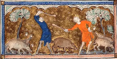
Around 790 the Saxon King Offa of Mercia built his dyke high above the Wye, to mark the boundary with the Welsh. The Forest of Dean then came under the control of the diocese of Hereford. Throughout the next few centuries Vikings conducted raids up the Severn, but by the 11th century the kingdom of Wessex had established civil government. The core of the forest was used by the late Anglo Saxon kings, and after 1066 the Normans, as their personal hunting ground. The area was kept stocked with deer and wild boar and became important for timber, charcoal, iron ore and limestone.

The Hundred of St Briavels was established in the 12th century, at the same time as many Norman laws concerning the Forest of Dean were put in place. St Briavels Castle became the Forest's administrative and judicial centre. Verderers were appointed to act for the king and protect his royal rights, and local people were given some common rights.

Flaxley Abbey was built and given rights and privileges. In 1296, miners from the Hundred of St Briavels supported King Edward I at the siege of Berwick-on-Tweed in the Scottish Wars of Independence by undermining the then Scottish town's defences in the first step of his campaign to seize Scotland from John Balliol. As a result, the king granted free mining rights within the forest to the miners and their descendants; the rights continue to the present day. Miners at that time were mainly involved in iron mining although the presence of coal was well known and limited amounts had been recovered in Roman times. Coal was not used for iron making with the methods of smelting then in use. Later the freeminer rights were used mainly for coal mining. The activities of the miners were regulated by the Court of Mine Law.

Forest of Dean - Wikipedia

𝕸 Economy

Economic History ..
Economy of Roman Empire 
European Bank Money Creation - History ..
guild ..
Medieval Banking ..
Papyrus .. 

Circular Economy 

Forest Law & Forest of Dean

Magna Carta concession to forest access > .
Magna Carta accedes to dis-afforestation > .
What was the Charter of the Forest? | Magna Carta Series > .
Carta Foresta 1217 - TrId >> .

Ray Mears: Forest of Dean Wild Britain S01E01 Deciduous Forest
https://www.youtube.com/watch?v=bhnBhObR5QU

The Forest of Dean lies in west Gloucestershire in the angle formed by the rivers Severn and Wye as they approach their confluence. A large tract of woodland and waste land there was reserved for royal hunting before 1066 and survived into the modern period as one of the principal Crown forests in England, the largest after the New Forest. The name Forest of Dean was recorded from c. 1080 and was probably taken from the valley on the north-east of the area, where a manor called Dean was the Forest's administrative centre in the late 11th century.

In modern times the name Forest of Dean was sometimes used loosely for the part of Gloucestershire between the Severn and Wye, but all that land belonged to the Forest (used in the specific sense of the area subject to the forest law) only for a period in the early Middle Ages. In the 13th century the Forest's bounds were the two rivers and it extended northwards as far as Ross-on-Wye (Herefs.), Newent, and Gloucester; it then included 33 Gloucestershire and Herefordshire parishes, besides a central, uncultivated area which the Crown retained in demesne. Revised bounds, perambulated in 1300 and accepted by the Crown in 1327, reduced the extent of the Forest to the royal demesne and 14 parishes or parts of parishes, most of them, like the demesne itself, in St. Briavels hundred. The royal demesne remained extraparochial until the 1840s when, villages and hamlets having grown up within it, it was formed into the civil townships (later parishes) of East Dean and West Dean and into ecclesiastical districts.
......
The formerly extraparochial land of the Forest of Dean lies mainly at over 200 m. (656 ft.), reaching its highest point, 290 m. (951 ft.), at Ruardean hill in the north. Sometimes described as a plateau but actually comprising steep ridges and the valleys of streams draining to the Severn and Wye, its boundaries with the surrounding cultivated and ancient parochial lands are in most places defined by a scarp where the underlying carboniferous limestone of the region outcrops. On the west, however, the limestone outcrops at a shallower angle and there is a less obvious distinction in height between the Forest and the cultivated land of the large ancient parish of Newland. The long valley of Cannop brook, earlier called the Newerne stream, crosses the west part of the Forest from north to south, and a stream called in its northern part Cinderford brook and in its southern Soudley brook forms a long winding valley through the east part. Blackpool brook, so called by 1282, carves another deep valley through the south-eastern edge of the high land to meet Soudley brook at Blakeney below the Forest's scarp, and at the Forest's northern edge Greathough brook, formerly Lyd brook, descends a valley to the Wye. The streams were dammed in places for ironworks, notably in the Cannop valley where two large ponds were made in the 1820s to provide power for works at Parkend. Other large ponds on a tributary stream of Soudley brook at Sutton bottom, near Soudley, were built as fishponds in the mid 19th century for a privately-owned estate in that part of the Forest called Abbots wood. In the late 20th century the Forestry Commission maintained the Forest's ponds as nature reserves and as a public amenity; new ones were made at Woorgreen, near the centre of the Forest, as part of landscape restoration following opencast coal mining in the 1970s, and at Mallards Pike, near the head of Blackpool brook, in 1980.

Geology has given the Forest its rich industrial history. The land is formed of basin-shaped strata of the Carboniferous series. Underlying and outcropping at the rim are limestones which, especially the stratum called Crease Limestone, contain deposits of iron ore. Above are beds of sandstone, shale, and coal. The lowest bed of sandstone is known by the local name of Drybrook Sandstone, and the highest is the Pennant Sandstone. There are over 20 separate coal seams, varying in thickness from a few inches to 5 ft., the highest yielding being the Coleford High Delf which rises close to the surface near the rim of the Forest. Surface workings, shallow pits, or levels driven into the hillsides were the means of winning the iron ore and coal until the late 18th century when deeper mines were sunk. There were also numerous quarries, notably those in the Pennant Sandstone at Bixhead and elsewhere on the west side of the Cannop valley; that stone, which varies in colour but is mainly dark grey, was the principal building material used in the Forest's 19th-century industrial hamlets.

The Forest was most significant as a producer of oak timber, which was the principal reason for its survival in the modern period. Until the early 17th century, however, there was as much beech as oak among its large timber trees, and chestnut trees once grew in profusion on the north-east side of the Forest near Flaxley and gave the name by 1282 to a wood called the Chestnuts. The underwood was composed of a variety of small species such as hazel, birch, sallow, holly, and alder. The ancient forest contained many open areas. In 1282 various 'lands', or forest glades, maintained by the Crown presumably as grazing for the deer, included several with names later familiar in the Forest's history, Kensley, Moseley, Cannop, Crump meadow, and Whitemead (later a part of Newland parish). Numerous smaller clearings called 'trenches' had also been made as corridors alongside roads for securing travellers against ambush or for the grazing and passage of the deer. Larger areas of waste, or 'meends', such as Clearwell Meend and Mitcheldean Meend, lay on the borders adjoining the manorial lands, whose inhabitants used them for commoning their animals.

Although the royal demesne land was without permanent habitation until the early modern period, it was crossed by many ancient tracks, used by ironworkers, miners, and charcoal burners; large numbers, many termed 'mersty' (meaning a boundary path), were recorded in 1282 in a perambulation of the Forest bailiwicks, its administrative divisions. One of the more important ancient routes, known as the Dean road, had a pitched stone surface and borders of kerbstones. It ran between Lydney and Mitcheldean across the eastern part of the demesne by way of Oldcroft, a crossing of Blackpool brook, recorded as Blackpool ford in 1282, and a crossing of Soudley brook at Upper Soudley. The survival of much pitching and kerbing after the road went out of use in the turnpike era, and the possibility that it had linked two important Roman sites at Lydney and Ariconium, in Weston under Penyard (Herefs.), has led to the suggestion that it was a Roman road, though much of the stonework probably dates from the medieval and early modern periods; an estimate was made for renewing long stretches of the road, including the provision of new border stones, as late as the 1760s.

Two main routes crossed the extraparochial Forest from north-east to south-west and on them were sited the principal points of reference in a terrain with few landmarks. A route from the Severn crossing at Newnham to Monmouth recorded in 1255, when 'trenches' were ordered to be made beside it, was presumably that through Littledean, the central Forest, and Coleford. It entered over a high ridge west of Littledean, where a hermitage of St. White had been founded by 1225, and crossed Soudley (or Cinderford) brook at the place called Cinder ford in 1258, long before its name was taken by the principal settlement of the extraparochial Forest that formed on the hillside to the north-east of the crossing. Further west, near the centre of the Forest, the road passed the clearing called Kensley, where a courthouse stood by 1338 close to the site of the later Speech House, and crossed Newerne (or Cannop) brook at Cannop. The road emerged into the cultivated land of Coleford tithing at a place later called Broadwell Lane End, where a tree called Woolman oak in 1608 (fn. 34) was probably the 'W(o)lfmyen' oak which in 1282 was a landmark at the boundary of four of the Forest's bailiwicks. The other main route, recorded in 1282 as the high road to Monmouth, was that crossing the high north-western part of the extraparochial land from Mitcheldean, by way of Nailbridge, Brierley, Mirystock, where it crossed a tributary of Cannop brook above Lydbrook, to Coleford. The two remained the principal routes through the Forest but the northern one, described in the 1760s as the great road through the Forest from Gloucester to South Wales, was much altered in its course by later improvements.

The rivers Severn and Wye played a vital role in the development of Dean's industry but few of the various tracks and hollow ways that led from the central Forest to riverside landing-places and ferries were usable other than by packhorses before the 19th century. One of the few routes negotiable by wagons and timber rigs was the central main road out to Littledean with its branch down to Newnham; that was the usual route for carrying timber out of the Forest in 1737 when the Crown was asked to assist Newnham parish to repair part of it. Later in the 18th century a road leading from the south part of the woodlands by way of Parkend and Viney Hill to Gatcombe and Purton on the Severn became the principal route for timber destined for the naval dockyards.

The Crown's hunting rights, which provided the original motive for the Forest's preservation, were much used in the 13th century. The frequent orders made at the period for taking deer for gifts by the Crown and to meet the needs of the royal household suggest that fallow deer were the majority species in Dean, with red deer and roe present in smaller numbers. In 1278 the Forest was sufficiently well stocked for royal huntsmen to take 100 fallow bucks. At that period all three species of deer were classed as beasts of the forest, reserved for the exclusive use of the Crown, but roe were not classified as such after 1340.

http://www.british-history.ac.uk/vch/glos/vol5/pp285-294

Forest of Dean: Forest administration
http://www.british-history.ac.uk/vch/glos/vol5/pp354-377

Forest of Dean: search
http://www.british-history.ac.uk/search?query=forest%20of%20dean

Beachley Peninsula, Severn Estuary

Beachley Peninsula is the spit of land that marks the end of the river Wye's journey as it flows into the River Severn.
https://www.youtube.com/watch?v=3jv0ARETTbM


Chapel Rock was once the home of Tecla, a princess of Gwynedd who retired there as a hermit before being murdered by raiders from the sea. It is now allegedly haunted.

A chapel dedicated to St Twrog was later built on the rock but was ruined before the 18th century, a small modern lighthouse now stands adjacent to the ruins.
https://www.youtube.com/watch?v=tm25jpUl7kI

The Rusting Severn Princess Ferry - River Wye Chepstow
https://www.youtube.com/watch?v=RaxbDalWI3I


#pRivSv River Severn Estuary - Extreme Spring Tides- Lydney Wellhouse Rock X6 & real time
https://www.youtube.com/watch?v=olNxez5zg8k

River Severn - Extreme Tides Bores & Spring Tide Floods
https://www.youtube.com/watch?v=njY2oOCATR8


Intertidal mudflats and sandflats are submerged at high tide and exposed at low tide. They form a major component of estuaries and large shallow inlets and bays in the UK but also occur extensively along the open coast and in lagoonal inlets. The physical structure of the intertidal flats ranges from mobile, coarse-sand beaches on wave-exposed coasts to stable, fine-sediment mudflats in estuaries and other marine inlets. This habitat type can be divided into three broad categories- clean sands, muddy sands and muds – although in practice there is a continuous gradation between them. Within this range, the flora and faunal communities vary according to the type of sediment, its stability and the salinity of the water. #pRivSv

The intertidal part of the Severn Estuary supports extensive mudflats and sandflats. These cover an area of approximately 20,300 ha – the fourth largest area in a UK estuary. It represents approximately 7% of the total UK resource of intertidal mudflats and sandflats and approximately 10% of the UK Natura 2000 resource, by area. There are extensive mudflats fronting the Welsh shore and Bridgwater Bay, and large banks of clean sands in the more central parts of the Estuary at Middle and Welsh Grounds.

The high biomass of invertebrates in the mudflats of the Severn provide an important food source for a diverse range and large number of fish and benthic predators. These intertidal areas are therefore important in supporting the fish assemblage sub-feature of the SAC and Ramsar Site.

Mudflats also provide a valuable feeding, roosting and resting area for a wide range of species of wading birds and waterfowl and are therefore important supporting habitats for the wintering and passage bird features of the SPA and Ramsar Site. The type of sediment, its stability and the salinity of the water have a large influence on the wildlife species present.
https://www.asera.org.uk/features/habitats-2/intertidal-mud-sand-flats/
..........
Over 80 species of fish have been recorded in the Severn Estuary. These include several migratory species such as salmon, sea trout, sea and river lampreys and in particular the UK priority species, allis and twaite shad. The estuary supports internationally important wildfowl and wader populations, in particular resident shelduck, winering dunlin, white-fronted goose, gadwall, and redshank, and Bewick’s swan, and provides a key staging ground during migration for species such as ringed plover and whimbrel.

The saltmarshes support significant populations of nationally scarce plant species including slender hare’s-ear, sea clover and bulbous foxtail, and are used for feeding by ducks and roosting by waders. Maritime cliffs, such as those found at Steepholm, Middlehope, Battery Point, Aust and between Clevedon and Portishead, contribute to the habitat diversity and provide roosting areas for birds, including nesting peregrines. A number of sites along the estuary are of national importance for their geology, including the Aust cliffs. There are several extensive Sabellaria reefs offshore which provide habitat for a wide diversity of invertebrates.

http://www.avonwildlifetrust.org.uk/what-we-do/we-create-living-landscapes-living-seas/severn-estuary

http://www.avonwildlifetrust.org.uk/wildlife/species-a-z

Intertidal Mudflats
Macoma balthica, Cersatoder ma edule, Retusa obtusa,
Hydrobia ulvae, Scrobiculari a plana

Subtidal Mobile Sandbank
Venus spp. (e.g.striatula), Fabulina fabula, Dosinia lupinus, Gari fervensis, Abra prismatica, Ensis ensis, Spisula spp.

http://www.ukmarinesac.org.uk/pdfs/sandmud.pdf

Winkles & Limpets
https://www.youtube.com/watch?v=DemRJlxXA1I

Shellfish UK !
https://www.youtube.com/watch?v=AN5OZn7M318

https://www.asera.org.uk/features/habitats-2/intertidal-mud-sand-flats/
https://naturalhistory.museumwales.ac.uk/britishbivalves/browserecord.php?-recid=58
http://www.marinespecies.org/aphia.php?p=taxdetails&id=141436

https://naturalhistory.museumwales.ac.uk/BritishBivalves/recordlist.php?-max=100&-skip=0&-sortfieldone=British%20Bivalve::Superfamily&-sortorderone=ascend&-sortfieldtwo=British%20Bivalve::Family&-sortordertwo=ascend&-sortfieldthree=British%20Bivalve::ScientificName&-sortorderthree=ascend
https://www.youtube.com/watch?v=qRbkZlsw_KE
https://en.wikipedia.org/wiki/Severn_Estuary

Forest of Dean map


Topographic map of Forest of Dean .

Forest of Dean - Puzzlewood

Puzzlewood - Forest of Dean
https://www.youtube.com/watch?v=jNyySzl1rhQ

Historic locations - Forest of Dean, Severn, Thames, Wye

Gloucestershire - Cotswolds, Forest of Dean, Puzzlewood, Severn, Wye - antharch
https://www.youtube.com/playlist?list=PLEFMsUiiH113wwhM2WOf5MW5R6giKrNep
Hundred of Westbury – BHO

St Briavel’s Hundred

Topographic map - Forest of Dean
http://en-gb.topographic-map.com/places/Forest-of-Dean-895886/
Topographic map - Forest of Dean - Google
https://www.google.ca/maps/place/Forest+of+Dean/@51.7853065,-2.7416215,11z/data=!3m1!4b1!4m5!3m4!1s0x4871bbac8be19677:0x2cdf3e955b6917e8!8m2!3d51.7999835!4d-2.5519169!5m1!1e4

Severn Estuary


Berkeley, Berkeley Pill, Little Avon


Forest of Dean, Severn, Wye
https://www.youtube.com/playlist?list=PL745-VcJ1xdVWspGTmRKxv9iZmw0xEtPG

Gloucestershire - Cotswolds, Forest of Dean, Puzzlewood, Severn, Wye - antharch
https://www.youtube.com/playlist?list=PLEFMsUiiH113wwhM2WOf5MW5R6giKrNep

Forest of Dean - ironworking

Forest of Dean - ironworking

Forest of Dean

http://www.wealdeniron.org.uk/Forest%20of%20Dean.htm
I’ve just come back from a rather lovely holiday in the Forest of Dean, the small triangle of land between the rivers Wye and Severn. As you’d expect, it’s mostly forest – pretty good forest in fact, so good for shipbuilding that it was explicitly noted as a target for the Armada. But the tranquility of the forest today belies the mass of industry beginning with Roman coal and ironworking, through to some of the earliest developments in tramroad building, steelworking and mass coal production, so that by 1945 half of the male population of the region were employed in the coal industry. The following year saw the closure of the last ironworks, and by 1965 the last of the major collieries shut.

As such, the area bears a lot of resemblance to my beloved Black Country. Despite a very different physical environment, many of the characteristics of industrial regions are shared with the Black Country, with the proto-industrial regions of the North, with the tin-mining regions of Cornwall etc. The towns in the forest are overgrown hamlets, populated when industry arrived, as compared to the older market towns of Ross or Monmouth, nearby. That means the housing and industry sprawl around the edges of the plantations, that there are large areas of reclaimed industrial land and that remains of this history can come upon you unexpectedly.

We stayed in the hamlet of Ellwood, south-east of Coleford. Driving in, it’s an unassuming place: sheep wander the roads, there’s a village school, a Methodist and a Christadelphian chapel, houses scattered rather haphazardly, all surrounded by vast, mixed forests. The clues are there though. Those chapels represent working class religion, not state-sponsored: Methodism and the various streams of unitarianism were strongly linked to working class populations. Opposite the cottage is a grassy knoll – less like that of Dallas 1963, more like a grassed over refuse heap from a colliery. And behold, the OS first revision from 1903 reveals an engine house, refuse heap and coal level disappearing into the hillside, likely to be part of either the Hopewell or Ellwoodgreen Collieries nearby. Looking at the photo above also gives you some idea of how the topography of the land can strongly suggest its previous uses.

Venture through the woods and you’ll find the ruins of a large stone structure – again, this is clearly marked on the old maps as the Darkhill Ironworks, a place of massive significance in the industrial history of this country, where David Mushet and his sons opened an experimental furnace given over more to R&D than to production, working with alloys and “Mushet Steel”. The path around this is the former Severn & Wye Railway branch to Coleford.

Aside from the obvious difference that there’s a forest in one and not in the other, there seems to me a great deal of spatial similarity between the Forest of Dean and the Black Country. Both were the site of pioneering advances in industry and technology, and whose landscapes are permanently marked by their human history as well as their natural. Compare the Black Country Landscape Characterisation with the Forest of Dean; you could get some serious meta-analysis out of there. Although the Black Country has taken on a much more urban character since industrialisation, I’d be interested to see if the same issues affect both areas now: practical ones like where and how to build housing when there’s mines everywhere underneath; societal ones like a culture of identity within the area; even economic ones – I wonder if this out-of-the-way part of Gloucestershire sees any of the economic deprivation of the built-up Black Country.
https://uptheossroad.wordpress.com/2014/05/29/ellwood/

Forest of Dean

Forest of Dean, Gloucester, Gloucestershire

Agisters, Verderers, Medieval Forest of Dean .. Clearwell Caves, Forest of Dean, Gloucestershire .. Forests & Chases - Medieval & Green .. Forest of Dean Ironworking .. Hundred of Westbury .. Hundred, St Briavels ..
Forest of Dean maps
1282

modern map

Forest of Dean - ironworking

Topographic Maps - Forest of Dean
https://www.royalforestofdean.info/maps/
https://www.google.ca/maps/@54.767101,2.5694109,6.25z
Forest of Dean 1282 = pre-perambulation

Ray Mears: Forest of Dean Wild Britain S01E01 Deciduous Forest
https://www.youtube.com/watch?v=bhnBhObR5QU
St Briavels Hundred

Westbury Hundred

Gloucester
Gloucester, intramural

Gloucester, Medieval, simple map

Gloucester, Lower Westgate, Bareland St Nicholas's

Gloucester, Broadsmith, Bull Lane, Cross Keys, Longsmith

Gloucester, St Peter's Abbey

Gloucester Oxbode Rosse

Gloucester, tannery area, Alvyn Gate

Llanthony Secunda Priory & Religious Houses

Llanthony Secunda Priory - reconstruction

Agisters, Archaeology, Forests, History, Hunters, Ironworkers, Miners, Verderers, Woodsmen - LINKS

The Verderers in the Forest of Dean have been in existence since at least 1218 and are charged with protecting the vert and venison (that is, generally, the vegetation and habitat) of the Forest. They are the last remnant of the traditional forest administration – unlike the New Forest, their structure has been unaltered over the centuries – there are still four verderers just as there has been for the past 800 years. The Verderers are elected by the freeholders of Gloucestershire at the Gloucester Court (an ancient procedure in its own right) and serve for life. Over the years, the deer in the Forest of Dean have fluctuated in numbers and species (they were totally absent for about 90 years from 1855) but today a herd of about 400 fallow deer inhabits the Forest. The Verderers now meet quarterly in their courtroom in the Speech House, close to the centre of the Forest.
https://en.wikipedia.org/wiki/Verderer#Forest_of_Dean_Verderers
http://www.deanverderers.org.uk/verderers-history.html
https://en.wikipedia.org/wiki/Reeve_(England)

Forests, Woodsmen, Hunters, Miners, Ironworkers
https://www.youtube.com/playlist?list=PL745-VcJ1xdWc4CiWxovU2RNTVn4FvsOT
Forest & Woodland Resources - LINKS

Town & Country: Forests, Woodsmen, Hunters - LINKS

Intensification: Oasthouses


Wye Valley Woodland (AONB) Wales - Trees woods & forest gardens - agroforestry arboriculture
https://www.youtube.com/playlist?list=PL3hm4LtH_-dogYqTZdrKfhRCUNlwowYmq

Charcoal, coppice, edibles, timber - Tony Blake
https://www.youtube.com/playlist?list=PLtakTnKQQMCzq3gN7I0H5RaM8_DCFWpPz

Ancient Woodland & Value of Trees - antharch
https://www.youtube.com/playlist?list=PLEFMsUiiH110nbFULj5JDl_0nqdm4tbdx


Bite sized New Forest - New Forest National Park Authority
https://www.youtube.com/playlist?list=PLPERa4Ls5ArrEIV-owtlAIcVPAhcbNC2p

The Weald

https://www.youtube.com/user/highwealdAONB/videos

Hunting scene - Archaeology & History of Medieval Sherwood Forest
http://news.experiencenottinghamshire.com/archaeology-and-history-of-medieval-sherwood-forest/

Topographic map - Forest of Dean

http://en-gb.topographic-map.com/places/Forest-of-Dean-895886/

Topographic map - Forest of Dean - Google

https://www.google.ca/maps/place/Forest+of+Dean/@51.7853065,-2.7416215,11z/data=!3m1!4b1!4m5!3m4!1s0x4871bbac8be19677:0x2cdf3e955b6917e8!8m2!3d51.7999835!4d-2.5519169!5m1!1e4

Forest of Dean 1282 = pre-perambulation \/

Forest of Dean