Agas Map of Early Modern London ..
Great Fire of London, 1666 ..
London - Early & Early Modern London ..
London - Early Modern ..
London - Tudor ..

Agas Map of Early Modern London
Agas Map of Early Modern London
http://mapoflondon.uvic.ca/agas.htm?
Walking distance in medieval Europe versus modern decentralizing technologies
http://mapoflondon.uvic.ca/agas.htm?
Walking distance in medieval Europe versus modern decentralizing technologies

Great Fire of London, 1666
National Geographic Great Fire of London The Untold Story > .
Great Fire of London in 1666 - LaHa >> .
Great Fire of London in 1666 - LaHa >> .
https://www.thegreatcoursesdaily.com/great-fire-london/
London - Early & Early Modern London
London
Early & Early Modern London
https://mittelzeit.blogspot.com/2017/11/london-early-modern.html
London - Tudor
https://mittelzeit.blogspot.com/2019/03/london.html
Historic London
https://www.thegreatcoursesdaily.com/history-of-london/
City Of London As In Q. Elizabeth's Time
1868
Great Fire of London
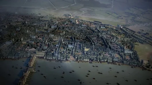
A few days after the fire’s end on September 5th, 1666, several plans for rebuilding the gutted City, with imaginative street layouts, were submitted to Charles II by figures including the architect Christopher Wren, the natural philosopher Robert Hooke and the surveyor Peter Mills. None was used, as they all proved impractical for various reasons, but in order for rebuilding to happen accurate plans were needed.
The king ordered a survey and the results were drawn up on six plates by John Leake in March 1667. Wenceslaus Hollar produced the engraving and added to it contrasting views of the City from Southwark, on the south bank of the Thames, before and after the fire. No copy of that original map survives but a reduced version, dedicated to Sir William Turner, then Lord Mayor of London, was issued in 1669.
http://www.historytoday.com/kate-wiles/great-fire-london
City of London
https://www.google.ca/maps/place/City+of+London,+London,+UK/@51.5150566,-0.1020399,15z/data=!3m1!4b1!4m5!3m4!1s0x487603554edf855f:0xa1185c8d19184c0!8m2!3d51.5123443!4d-0.0909852?hl=en
Leake's Survey of the City After the Great Fire of 1666 Engraved By W. Hollar, 1667
http://www.british-history.ac.uk/no-series/london-map-leake/1667
Ogilby and Morgan's Large Scale Map of the City As Rebuilt By 1676
http://www.british-history.ac.uk/no-series/london-map-ogilby-morgan/1676
Morgan's Map of the Whole of London in 1682
http://www.british-history.ac.uk/no-series/london-map-morgan/1682
-------
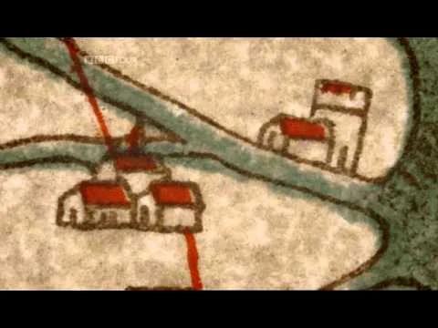
The Agas Map of Early Modern London
(image 1666 imagined)
http://www.british-history.ac.uk/no-series/london-map-agas/1561
Civitas Londinum is a bird’s-eye view of London first printed from woodblocks in about 1561. Widely known as the Agas map, from a spurious attribution to surveyor Ralph Agas (c.1540-1621), the map offers a richly detailed view both of the buildings and streets of the city and of its environment. No copies survive from 1561, but a modified version was printed in 1633. In the later version of the map, the Stuart coat of arms replaces the Elizabethan arms, and the Royal Exchange, which opened in 1571, occupies the triangle created by the convergence of Threadneedle and Cornhill Streets.
http://mapoflondon.uvic.ca/agas.htm?
https://plus.google.com/+SuttonHoo/posts/Wm7bGwT1ata
https://mapoflondon.uvic.ca/GLOSS1.htm
https://mapoflondon.uvic.ca/mdtEncyclopediaLocation.htm?listType=subcategory
https://mapoflondon.uvic.ca/historical_personography.htm
https://mapoflondon.uvic.ca/ORGS1.htm
https://mapoflondon.uvic.ca/mdtEncyclopediaTopic.htm
James De La Feuille's Map of London c. 1690
http://www.british-history.ac.uk/no-series/london-map-de-la-feuille/1690
The London Time Machine - 1682
http://maps.arcgis.com/apps/StorytellingSwipe/index.html?appid=e5160a8d1d3649f09a756c317bd0b56b#
http://www.arcgis.com/features/maps/index.html
"William Morgan's Map of London 1682 - The Beauty of Maps - Episode 2 - BBC Four"
https://www.youtube.com/watch?v=CtaWEiK77TI
https://www.youtube.com/watch?v=CtaWEiK77TI&list=PL8418C0F0EB1AF70D&index=3
https://plus.google.com/118077931144377065433/posts/52fH3zqcsMs
Gough map: 14th century England
https://plus.google.com/118077931144377065433/posts/E8fZaehWLyw
London Evolution Animation
https://www.youtube.com/watch?v=nsci5Wh3Mww
https://plus.google.com/118077931144377065433/posts/JBQuQj9569W
Early & Early Modern London
https://mittelzeit.blogspot.com/2017/11/london-early-modern.html
London - Tudor
https://mittelzeit.blogspot.com/2019/03/london.html
Historic London
https://www.thegreatcoursesdaily.com/history-of-london/
City Of London As In Q. Elizabeth's Time
1868
Great Fire of London
A few days after the fire’s end on September 5th, 1666, several plans for rebuilding the gutted City, with imaginative street layouts, were submitted to Charles II by figures including the architect Christopher Wren, the natural philosopher Robert Hooke and the surveyor Peter Mills. None was used, as they all proved impractical for various reasons, but in order for rebuilding to happen accurate plans were needed.
The king ordered a survey and the results were drawn up on six plates by John Leake in March 1667. Wenceslaus Hollar produced the engraving and added to it contrasting views of the City from Southwark, on the south bank of the Thames, before and after the fire. No copy of that original map survives but a reduced version, dedicated to Sir William Turner, then Lord Mayor of London, was issued in 1669.
http://www.historytoday.com/kate-wiles/great-fire-london
City of London
https://www.google.ca/maps/place/City+of+London,+London,+UK/@51.5150566,-0.1020399,15z/data=!3m1!4b1!4m5!3m4!1s0x487603554edf855f:0xa1185c8d19184c0!8m2!3d51.5123443!4d-0.0909852?hl=en
Leake's Survey of the City After the Great Fire of 1666 Engraved By W. Hollar, 1667
http://www.british-history.ac.uk/no-series/london-map-leake/1667
Ogilby and Morgan's Large Scale Map of the City As Rebuilt By 1676
http://www.british-history.ac.uk/no-series/london-map-ogilby-morgan/1676
Morgan's Map of the Whole of London in 1682
http://www.british-history.ac.uk/no-series/london-map-morgan/1682
-------
The Agas Map of Early Modern London
(image 1666 imagined)
http://www.british-history.ac.uk/no-series/london-map-agas/1561
Civitas Londinum is a bird’s-eye view of London first printed from woodblocks in about 1561. Widely known as the Agas map, from a spurious attribution to surveyor Ralph Agas (c.1540-1621), the map offers a richly detailed view both of the buildings and streets of the city and of its environment. No copies survive from 1561, but a modified version was printed in 1633. In the later version of the map, the Stuart coat of arms replaces the Elizabethan arms, and the Royal Exchange, which opened in 1571, occupies the triangle created by the convergence of Threadneedle and Cornhill Streets.
http://mapoflondon.uvic.ca/agas.htm?
https://plus.google.com/+SuttonHoo/posts/Wm7bGwT1ata
https://mapoflondon.uvic.ca/GLOSS1.htm
https://mapoflondon.uvic.ca/mdtEncyclopediaLocation.htm?listType=subcategory
https://mapoflondon.uvic.ca/historical_personography.htm
https://mapoflondon.uvic.ca/ORGS1.htm
https://mapoflondon.uvic.ca/mdtEncyclopediaTopic.htm
James De La Feuille's Map of London c. 1690
http://www.british-history.ac.uk/no-series/london-map-de-la-feuille/1690
The London Time Machine - 1682
http://maps.arcgis.com/apps/StorytellingSwipe/index.html?appid=e5160a8d1d3649f09a756c317bd0b56b#
http://www.arcgis.com/features/maps/index.html
"William Morgan's Map of London 1682 - The Beauty of Maps - Episode 2 - BBC Four"
https://www.youtube.com/watch?v=CtaWEiK77TI
https://www.youtube.com/watch?v=CtaWEiK77TI&list=PL8418C0F0EB1AF70D&index=3
https://plus.google.com/118077931144377065433/posts/52fH3zqcsMs
Gough map: 14th century England
https://plus.google.com/118077931144377065433/posts/E8fZaehWLyw
London Evolution Animation
https://www.youtube.com/watch?v=nsci5Wh3Mww
https://plus.google.com/118077931144377065433/posts/JBQuQj9569W
London - Early Modern
Early Modern London
http://mapoflondon.uvic.ca/agas.htm
http://mapoflondon.uvic.ca/mdtEncyclopediaTopic.htm
The City Of London As In Q. Elizabeth's Time #pLndn #rgEiT
http://mapco.net/london.htm
http://mapco.net/londonstrype/strype.htm
William Fitzstephen, Description of London, c. 1173
http://www.trytel.com/~tristan/towns/florilegium/introduction/intro01.html

Cosmeston Medieval Village is a "living history" medieval village near Lavernock in the Vale of Glamorgan not far from Penarth and Cardiff in south Wales.
https://www.youtube.com/watch?v=rSy48H2ocSc
https://en.wikipedia.org/wiki/Cosmeston_Medieval_Village
http://www.valeofglamorgan.gov.uk/en/enjoying/Coast-and-Countryside/cosmeston-lakes-country-park/cosmeston-medieval-village/Cosmeston-Medieval-Village.aspx
London - Tudor

The Natural Environment of Tudor London > .https://www.youtube.com/watch?v=n-YGW8qIq9Q .
The Agas Map of Early Modern London
http://mapoflondon.uvic.ca/agas.htm?
Elizabethan London
http://mapco.net/londonstrype/strype.htm
"Tudor London - Pool of London to London Bridge"
https://www.youtube.com/watch?v=zFatTus8UXw
"Tudor London - Pool of London"
https://www.youtube.com/watch?v=7CT2TL_ugkE
"Tudor London"
https://www.youtube.com/watch?v=w5dkVP6q_s8
London - Tam playlist
https://www.youtube.com/playlist?list=PLs5H4V1x-xBgI-S88AM9pxZT7RGVfTeIw
Flyround & Hyperlapse - Tam playlist
https://www.youtube.com/playlist?list=PLs5H4V1x-xBjJjDSdn3gYEWWjzHcgKQie
CGI, animations, models - England, Europe, Norse
https://www.youtube.com/playlist?list=PLtakTnKQQMCx_8UAVnpmOgrZ7xU8-ja2H
"Medieval London: A Collection of Precincts - Dr Simon Thurley" - GreshamCollege
https://www.youtube.com/watch?v=EEdj0o_AVPM
"The Building of England: Retrospect and Prospect 410 AD to 2000 - Dr Simon Thurley" - GreshamCollege
https://www.youtube.com/watch?v=nLvsD6qS030
https://www.youtube.com/watch?v=CtaWEiK77TI&list=PL8418C0F0EB1AF70D&index=3

Subscribe to:
Posts (Atom)