Showing posts with label map. Show all posts

Cantref


Land in medieval Wales was divided into cantrefi, which were themselves divided into smaller cymydau (commotes). The word cantref is derived from cant ("a hundred") and tref ("town" in modern Welsh, but formerly used for much smaller settlements). The cantref is thought to be the original unit, with the commotes being a later division. Cantrefi could vary considerably in size: most were divided into two or three commotes.

The antiquity of the cantrefi is demonstrated by the fact that they often mark the boundary between dialects. Some were originally kingdoms in their own right; others may have been artificial units created later.

Cantrefi were of particular importance in the administration of the Welsh law. Each cantref had its own court, which was an assembly of the uchelwyr, the main landowners of the cantref. This would be presided over by the king if he happened to be present, or if he was not present, by his representative. Apart from the judges there would be a clerk, an usher and sometimes two professional pleaders. The cantref court dealt with crimes, the determination of boundaries, and inheritance. The commote court later took over many of the functions of the cantref court, and in some areas the names of the commotes are much better known than the name of the cantref of which they formed parts.

Љ Hereford, 1290 Expulsion

Hereford

Љ Hereford ..
The Jewish Community in Hereford (England), up to 1290.

The Expulsion

In 1290, Edward I sent secret orders to the sheriff that all Jews, with their wives, children and chattels, were, on pain of death, to quit the realm by 1 November, the feast of All Saints. The sheriff was to ensure that they suffered no injury, harm, damage or grievance in their departure. The penalty for any Jew who remained behind after that was death.

Paris was the goal of the wealthiest, but in February 1291 Philip the Fair expelled all English Jews from his lands except those profitable to the French crown . It is not known what became of Hereford's Jews.

· The Expulsion was announced on 18th April, which, that year, fell on the 9th of Av, on the Jewish calendar. The 9th of Av is Tisha BaAv, a day of fasting, since it was also the date of the destruction of 1st and 2nd Temples. (see Jewish Feasts or holidays )

http://www.wildolive.co.uk/hereford_history.htm
https://en.wikipedia.org/wiki/Statute_of_the_Jewry
https://en.wikipedia.org/wiki/Edict_of_Expulsion

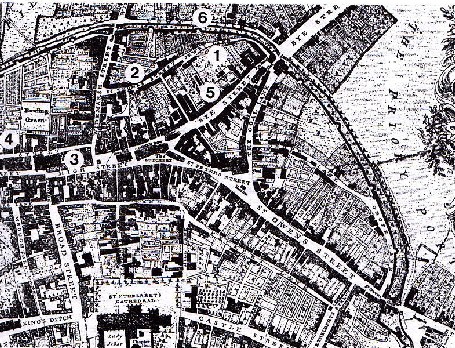
The Location of Hereford’s Jewry

English medieval Jewries were not ghettos.
1 Jewry Lane - centre of the community.
2 Maylord Street
3 Home of Moses -leader of community
4 Bewell Spring -site of mikveh?
5 Bye Street - home of Manasser and house in dowry of daughter of Hamo.
6 Bastion known as the Jew's Chimney
Off South East corner - site of cemetery

Archaeology has not produced much evidence but records can tell us quite a lot.

After the expulsion, Reginald Moniword and William de Pedwardyn bought up Aaron's house, the synagogue and most of the other property in Hereford. The cemetery was incorporated into St. Giles' Hospital. Thus ended the 110-year-old community cherished first by Hamo and his family and later by Aaron. The community was remembered in common usage of place names for six centuries.

http://www.wildolive.co.uk/hereford_history.htm

http://www.wildolive.co.uk/images/Hereford%20Jewry.jpg .

Hereford
http://www.british-history.ac.uk/rchme/heref/vol1/pp90-144
secular
http://www.british-history.ac.uk/rchme/heref/vol1/pp90-144#h3-0003

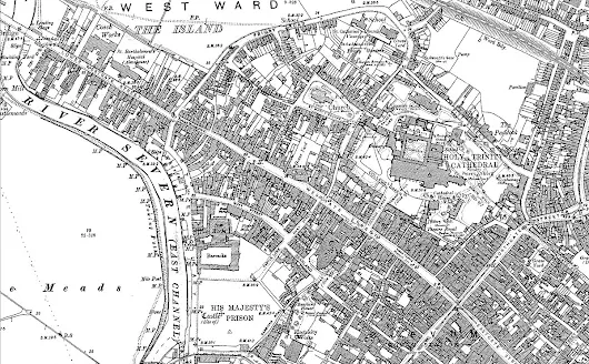
Map of Hereford, 1885 - 1886
https://www.francisfrith.com/hereford

https://en.wikipedia.org/wiki/Jewish_ghettos_in_Europe

https://en.wikipedia.org/wiki/Hereford
https://en.wikipedia.org/wiki/History_of_Herefordshire .

Medieval Antisemitism: An Introduction ~Dr Lackner >

Magellan - Age of Exploration

.Magellan's Voyage: Why the Explorer Gets Too Much Credit > .

Ferdinand Magellan (Fernão de Magalhães, Fernando de Magallanes; 4 February 1480 – 27 April 1521) was a Portuguese explorer and Hispanic Monarchy's subject from 1518. He is best known for having planned and led the 1519 Spanish expedition to the East Indies across the Pacific to open a maritime trade route in which he discovered the interoceanic passage bearing thereafter his name and achieving the first European navigation from the Atlantic to Asia. This expedition, where Magellan was killed in battle against the natives of Mactan Island (present day Philippines) in 1521, resulted in the first circumnavigation of the Earth when one of the expedition's two remaining ships eventually returned to Spain in 1522.

Born 4 February 1480 into a family of minor Portuguese nobility, Magellan became a skilled sailor and naval officer and was in service of the Portuguese Crown in Asia. Confronted to some criminal offences and after King Manuel I of Portugal refused to support his plan to reach the Maluku Islands (the "Spice Islands") by sailing westwards around the American continent, Magellan left Portugal and proposed the expedition to King Charles I of Spain who accepted it. For this move, Magellan was henceforth considered by many in Portugal as a traitor and was never to return. He adopted the name of Fernando de Magellanes and settled in Seville where he married and fathered two children; and from where he organised the expedition. In consideration to the allegiance to the Hispanic Monarchy, Magellan was appointed in 1518 admiral of the Spanish Fleet to command the expedition, the five-ships Armada of Molucca, as well as Commander of the Order of Santiago, one of the highest military ranks of the Spanish Empire.

Granted with special powers and privileges by the King, he headed the Armada from Sanlucar de Barrameda south through the Atlantic Ocean to the eastern coast of South America down to the Patagonia. Despite a series of storms and mutinies, they made it through the Strait of Magellan into the Mar del Sur which he renamed the "Peaceful Sea" (the modern Pacific Ocean). The expedition reached Guam and shortly after, the Philippine islands, where Magellan was killed during the Battle of Mactan in April 1521. Under the command of captain Juan Sebastian Elcano, the expedition later reached the Spice Islands and, to navigate back to Spain and avoid seizure by the Portuguese, the two remaining ships split, one attempting unsuccessfully to reach New Spain sailing eastwards across the Pacific while the other, commanded by Elcano, sailed westwards via the Indian Ocean and up the Atlantic coast of Africa to finally arrive at the expedition's port of departure, completing the first circuit of the globe.

While at the Kingdom of Portugal's service, Magellan had already reached the Malay Archipelago in Southeast Asia on previous voyages traveling east (from 1505 to 1511–1512). By visiting this area again but now travelling west, Magellan achieved a nearly complete personal circumnavigation of the globe for the first time in history.

Rivers of Midlands

Severn
1 - Tern?
2 - Cound Brook?
3 - Worfe
4 - Mor Brook? Borle Brook
5 - Stour
6 - Salwarpe
7 - Teme
Warwickshire Avon
8 - Arrow?
9 - Stour?
10 - Alne?
Severn
11 - Chelt?
12 - Leadon
Thames (Isis)
13 - Coln
14 - Leech
15 - Windrush
16 - Evenlode
17 - Cherwell
18 - Thame


Medieval Gloucester: Topography


Medieval Gloucester: Topography
Gloucester

Gloucester ~ 1500


Westgate

Intramural

Alvyn Gate, tanneries

Broadsmith

St Peter's

Oxbode

Gloucester Castle

Gloucester Castle

There were 2 medieval castles in Gloucester’s history. The first or ‘old’ castle was mentioned in the Domesday Book – it lay to the east of the prison site and was built in the corner of the old Roman town walls. This was most probably of the wooden motte and bailey type.

The old castle was replaced by a new stone castle on the current site c. 1110-1120. The castle was a large structure, with the keep, ... an inner bailey and stables. The keep was surrounded by a series of concentric defences which comprised curtain walls and ditches, with the drawbridge and gatehouse lying outside the current site to the north.

The castle fell into decline during the later medieval period and was taken over as the county gaol during the reign of king Richard III (r. 1483-1485) with the castle keep being the main prison building.
http://cotswoldarchaeology.co.uk/excavating-gloucester-prison/
http://www.follypublications.co.uk/product/the-castles-of-gloucestershire-and-bristol/

18th century engraving of Gloucester from south
http://www.medart.pitt.edu/image/england/gloucester/cathedral/Glouc-SCENE-RGC-F2-b.jpg

Gloucester & Whitefriars

.
3D Reconstruction - Gloucester's Whitefriars Carmelite Priory - HiHi > .
         
Gloucester under Saxons and Normans

In the seventh century the Hwicce, a subordinate Saxon tribe of the Mercian dynasty, had settled in Gloucestershire and part of Worcestershire. In 679 Osric, king of the Hwicce, founded a monastery at Gloucester dedicated to St Peter on or near the site now occupied by the cathedral. By the tenth century the town was an important centre of the Kingdom of Mercia and had been re-fortified and re-planned by Queen Aethelflaeda, daughter of Alfred the Great, against the incursions of the Danish armies. The street plan of in Gloucester is a direct legacy of this revitalisation. She also founded the New Minster church of St Oswald, about 900, which became a national shrine following the installation of the bones of the seventh century king and saint.

During the reign of Edward the Confessor the great hall of the Royal Manor or Palace at Kingsholm became the regular meeting place of the King and the Great Council - the Witanagemot - raising the status of Gloucester to that of Winchester and London.

In 1066 William of Normandy claimed the English throne and continued the practice of holding meetings of the Great Council at Gloucester. It was at one such gathering in 1085 that William I called for the detailed survey of his kingdom resulting in the production the Domesday Book. The conqueror also had a profound effect on the religious life of Gloucester when he appointed Serlo of Bayeux, Norman monk, to restore the flagging fortunes of the near defunct abbey of St Peter. Serlo began by building the great abbey church in the Norman style and the huge pillars of the nave are an important feature in the present cathedral. Perhaps the first Norman building to be imposed on the town was a motte and bailey castle. The 20m. (65ft.) high mound was built in the south-west corner of the walled town and was topped with a timber tower with a defended enclosure bailey on its east side. This together with the rebuilding of some of the town gates became a symbol of the king s authority over, Indigenous Saxon population. The timber and earth castle was replaced in the early twelfth century by a large stone keep, complete with surrounding walls and deep moat, just to the west on the east bank of the River Severn.

In the dispute for the throne between King Stephen and Matilda, Robert Earl of Gloucester, supported his half-sister Matilda. The town transferred its allegiance from the king to Matilda but no fighting took place.

http://www.glosarch.org.uk/Gloucestercityresearch.html#MEDIEVAL

image: Visualisation of North West Gloucester in about 680 by Richard Bryant
http://www.glosarch.org.uk/GM&P3.jpg .


https://mittelzeit.blogspot.com/2019/03/gloucester-barton.html
https://mittelzeit.blogspot.com/2019/03/gloucester-broadsmith-bull-lane-cross.html
https://mittelzeit.blogspot.com/2019/03/gloucester-castle.html
https://mittelzeit.blogspot.com/2019/03/gloucester-cathedral.html
https://mittelzeit.blogspot.com/2019/03/gloucester-churches-parishes.html
https://mittelzeit.blogspot.com/2019/03/gloucester-intramural.html
https://mittelzeit.blogspot.com/2019/03/gloucester-lower-westgate-bareland-st.html
https://mittelzeit.blogspot.com/2019/03/gloucester-oxbode-rosse.html
https://mittelzeit.blogspot.com/2019/03/gloucester-southgate-street-and.html
https://mittelzeit.blogspot.com/2019/03/gloucester-st-peters-abbey.html
https://mittelzeit.blogspot.com/2019/03/gloucester-tannery-area-alvyn-gate.html
https://mittelzeit.blogspot.com/2019/03/gloucester-twyver-ladycroft.html
https://mittelzeit.blogspot.com/2019/03/gloucester-upper-westgate-cross.html
https://mittelzeit.blogspot.com/2019/03/gloucester-upper-westgate-street.html
https://mittelzeit.blogspot.com/2019/03/gloucester-westgate.html

Kingsholm Palace .. 

Gloucester & Barton

Barton: Old English bere-tūn, from bere ‘barley’ + tūn ‘enclosed piece of land, homestead, village’.

Gloucester in the Plantagenet and Tudor Period

Gloucester s importance was confirmed under the Plantagenets the grant of its first charter by Henry II in 1155, which gave the to privileges equal to those of Westminster and London. On 28th October 1216 the nine year old Henry III was led from the Royal Palace at Kingsholm to his coronation in St Peter's Abbey. He is the only English monarch since the Conquest to be crowned outside Westminster. Henry was a deeply religious man who did much the church in Gloucester during his long reign. It was he who was responsible for the grants of oaks from the Royal Forest of Dean for the building of the Dominican and Franciscan Friaries in the town. Remains of both houses survive: Blackfriars - England's most complete Dominican Friary dates from 1239 and Greyfriars from the rebuild of the early sixteenth century. The house of the Carmelites or Whitefriars erected just outside the north-east corner of the town wall was similarly endowed but today, sadly, no trace remains. Henry's zeal for establishing religious houses was tempered by his political troubles. By a strange quirk of fate the city of his coronation became his prison when in 1263 Simon de Montfort held him captive in Gloucester Castle during the Barons War. Many significant parliaments were held at Gloucester in the following one and half centuries including one held by Henry IV in 1407 which paved the way for bringing public finances under parliamentary control.

The fortunes of medieval Gloucester were strengthened in 1327 at when Abbot Thokey accepted for burial at St Peter's Abbey the body of King Edward II who was murdered at nearby Berkeley Castle. During the next two centuries many people were moved to make the pilgrimage to Edward's tomb, resulting in increased wealth and importance for the city and abbey. Craftsmen began restoring and beautifying the church and by the 1470s the building had reached its present size, complete with exquisite fan tracery in the cloisters and the glorious tower of Abbot Seabrooke. In this period other ancient city churches were also rebuilt and adorned with Perpendicular style towers.
http://www.glosarch.org.uk/Gloucestercityresearch.html

image: 1610

Gloucester churches & parishes

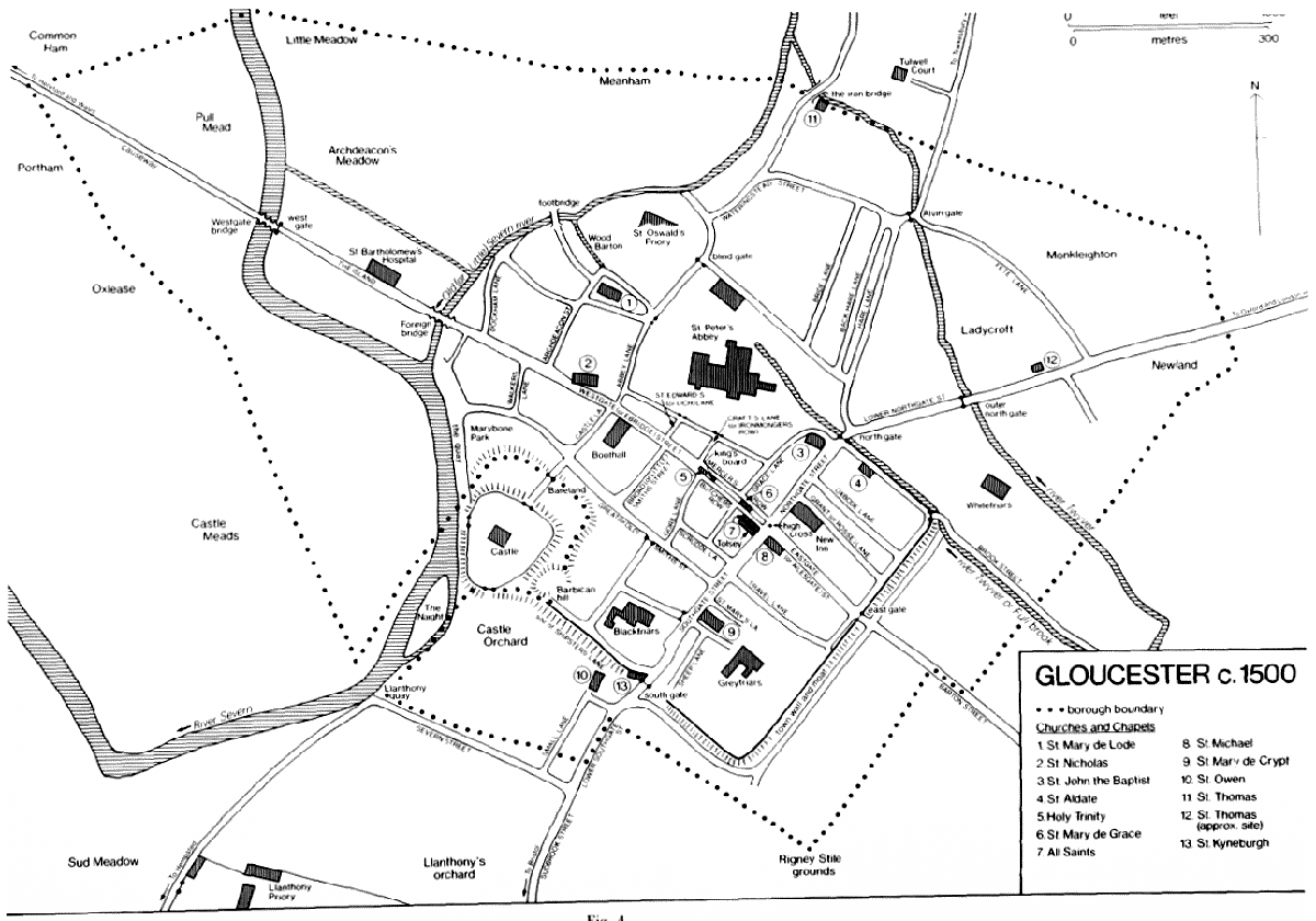
Gloucester ~ 1500

Gloucester: Topography

http://www.british-history.ac.uk/sites/default/files/publications/pubid-281/images/fig04.gif
http://www.british-history.ac.uk/vch/glos/vol4/pp63-72

1 St Mary de Lode
2 St Nicholas
3 St John the Baptist
4 St Aldate
5 Holy Trinity
6 St Mary de Grace
7 All Saints

8 St Michael
9 St Mary de Crypt
10 St Owen
11 St Thomas
12 St Thomas (approx. site)
13 St Kyneburgh

Maps of medieval Gloucester: Topography

1 St Mary de Lode
2 St Nicholas
3 St John the Baptist
4 St Aldate
5 Holy Trinity
6 St Mary de Grace
7 All Saints

8 St Michael
9 St Mary de Crypt
10 St Owen
11 St Thomas
12 St Thomas (approx. site)
13 St Kyneburgh

http://www.glosarch.org.uk/Gloucestercityresearch.html

Castles - beneath Gloucester prison
http://cotswoldarchaeology.co.uk/excavating-gloucester-prison/

#pGloc

Gloucester churches & parishes #pGloc #pRivSv #mbgge #minfr

Severn, bridge, castle, abbey, intramural, extramural suburbs

http://www.glosarch.org.uk/Gloucestercityresearch.html

Gloucester: Street names
http://www.british-history.ac.uk/vch/glos/vol4/pp364-368

Gloucester, tannery area, Alvyn Gate

Gloucester, tannery area, Alvyn Gate

Gloucester, Broadsmith, Bull Lane, Cross Keys, Longsmith

Gloucester, Broadsmith, Bull Lane, Cross Keys, Longsmith

Gloucester, St Peter's Abbey

Gloucester, St Peter's Abbey
Photo

Gloucester, Lower Westgate, Bareland St Nicholas's

Gloucester, Lower Westgate, Bareland St Nicholas's 

Gloucester, intramural

Gloucester
1720-1835
http://www.british-history.ac.uk/vch/glos/vol4/pp159-169

Gloucester - suburbs and outlying hamlets
Gloucester: Outlying hamlets
http://www.british-history.ac.uk/vch/glos/vol4/pp382-410
Barnwood
http://www.british-history.ac.uk/vch/glos/vol4/pp410-420


Gloucester, intramural
Photo

Gloucester, Westgate

Westgate, Gloucester - Wikipedia

Gloucester's importance was confirmed under the Plantagenets the grant of its first charter by Henry II in 1155, which gave the to privileges equal to those of Westminster and London. On 28th October 1216 the nine year old Henry III was led from the Royal Palace at Kingsholm to his coronation in St Peter's Abbey. He is the only English monarch since the Conquest to be crowned outside Westminster. Henry was a deeply religious man who did much the church in Gloucester during his long reign. It was he who was responsible for the grants of oaks from the Royal Forest of Dean for the building of the Dominican and Franciscan Friaries in the town. Remains of both houses survive: Blackfriars - England's most complete Dominican Friary dates from 1239 and Greyfriars from the rebuild of the early sixteenth century. The house of the Carmelites or Whitefriars erected just outside the north-east corner of the town wall was similarly endowed but today, sadly, no trace remains. Henry's zeal for establishing religious houses was tempered by his political troubles. By a strange quirk of fate the city of his coronation became his prison when in 1263 Simon de Montfort held him captive in Gloucester Castle during the Barons War. Many significant parliaments were held at Gloucester in the following one and half centuries including one held by Henry IV in 1407 which paved the way for bringing public finances under parliamentary control.

The fortunes of medieval Gloucester were strengthened in 1327 at when Abbot Thokey accepted for burial at St Peter's Abbey the body of King Edward II who was murdered at nearby Berkeley Castle. During the next two centuries many people were moved to make the pilgrimage to Edward's tomb, resulting in increased wealth and importance for the city and abbey. Craftsmen began restoring and beautifying the church and by the 1470s the building had reached its present size, complete with exquisite fan tracery in the cloisters and the glorious tower of Abbot Seabrooke. In this period other ancient city churches were also rebuilt and adorned with Perpendicular style towers.

http://www.glosarch.org.uk/Gloucestercityresearch.html#MEDIEVAL
https://en.wikipedia.org/wiki/Westgate,_Gloucester

Gloucester quay and docks
http://www.british-history.ac.uk/vch/glos/vol4/pp251-258

Hundred of Westbury

Hundred of Westbury

In 1066 Westbury hundred included Westbury, Churcham, Longhope, Bulley, the estates of Stears, Hyde, and Ruddle in Newnham, and probably Blaisdon, as part of Longhope, and Minsterworth, containing a total of 50 hides. The Forest of Dean manors of Dean and English Bicknor, containing three hides and a half yardland, were recorded as part of Westbury hundred in 1086, but Dean had been granted by Edward the Confessor free of geld, for the keeping of the forest. By 1221 English Bicknor and Dean, by then divided into Mitcheldean, Littledean, and Ruardean, lay in St. Briavels hundred. Westbury hundred was further reduced in area by the 15th century when the estates of the Duchy of Lancaster in Bulley, Longhope, Minsterworth, and Westbury came to be regarded as a separate hundred.

In 1066 Tidenham and Lancaut had formed Tidenham hundred, amounting to 30 hides, while Woolaston had been divided between Lydney hundred, which included the two estates at Aluredston in Woolaston, and Twyford hundred, which consisted of only two estates at Woolaston and Madgett amounting to no more than five hides. Tidenham hundred is not found recorded after 1086, and apparently was merged with Twyford hundred by the mid 13th century. During Henry III's reign Twyford hundred, as part of the marcher lordship of Striguil, was withdrawn from the county. It had presumably by then absorbed Aluredston, since the lord of Striguil's liberty was said to stretch from the Cone brook, which formed the eastern boundary of Woolaston, to Chepstow Bridge.

Westbury hundred belonged to the Crown, the sheriff accounting for the profits of courts in 1169 and holding courts in the late 18th century. Twyford hundred was held by the Crown until granted to the Earl Marshal, lord of Striguil, by Henry III, and descended with Striguil until its inclusion in Westbury in 1536.

No records of the Westbury hundred court have been found. In 1169 an income of 20s. was received from the court and in 1247 the jurors presented that the hundred was worth 2 marks a year. The court met every three weeks early in the 14th century. In common with the other hundreds west of the River Severn no Englishry was presented or murdrum fine due from the hundred in the 13th century.

The perquisites of the manor of Tidenham and hundred of Twyford were worth £68 8s. 3½d. in 1248, and in the late 13th century the reeve of Tidenham regularly accounted for pleas and perquisites of the manor and hundred courts.

In Westbury hundred the borough of Newnham was exempted from the hundred in the late 12th century, and in 1286-7 Edmund, Earl of Lancaster, claimed view of frankpledge, vetitum namium, and assize of bread and ale in his manors of Rodley and Minsterworth, which were exempt from all suits of shire and hundred.

The hundred meeting place cannot be identified with any certainty, but Malsdon in Bollow tithing in Westbury may have been the medieval site. The name of Twyford hundred is retained in a corrupt form as Wyvern Pond in Woolaston.

The parishes within the hundred lie in two groups west of the Severn on the relatively low ground between the tidal river and the higher land of the Forest of Dean and May Hill. The northern part of the hundred between Gloucester and Newnham is gently rolling, lowlying land which rises in only a few places more than 100 feet above sea level and is subject to seasonal flooding of meadows along the river and at Walmore in Westbury. Only in the western parts of Blaisdon and Newnham does the Keuper Marl and Lower Lias of the river basin give way to the Silurian limestones and shales and the Old Red Sandstone as the land rises steeply to the wooded hills adjoining the Forest of Dean. The southern part of the hundred containing Tidenham and Woolaston is of a different character. There is only a narrow belt of level riverside land formed of the Keuper Marl, and both parishes have a large proportion of hilly, wooded, and waste land which was chiefly within the medieval Tidenham Chase. Most of the Carboniferous Limestone plateau lies over 500 feet above sea level with cliffs up to 200 feet high dropping abruptly to the River Wye.

The settlements within the area are scattered, and apart from the former borough of Newnham the only nucleated villages are the small ones of Blaisdon and Westbury-on-Severn. There are numerous hamlets and isolated farms bearing witness to the lengthy process of clearing woodland; Welsh influence is recalled in the medieval place names of Walmore and Welchbury in Westbury, and Walleston in Newnham.

The River Severn, which in 1970 was not bridged between Gloucester and Chepstow and therefore formed a barrier to communication, was formerly of great economic importance to the hundred. Newnham had a thriving trade as a port, chiefly with towns up river, Bristol, and Ireland; there were other landing places at Cone Pill, Bullo Pill, and Broadoak, important ferries at Beachley and Newnham, and a number of lesser crossings; there was also considerable river traffic between the Wye valley and Bristol. Boat building and salmon and shrimp fishing were carried on extensively until the 19th century.

Much of the hundred formerly lay within the boundaries of the Forest of Dean, which at its most extensive in the 12th and 13th centuries included all or the greater part of the parishes in the hundred, but from 1300 the forest was usually more narrowly defined to exclude the whole hundred. There is evidence of widespread medieval assarting in Tidenham and Woolaston, but Tidenham Chase was not inclosed until 1815. Open fields existed in all the parishes and were mostly inclosed by a gradual process between the 15th and early 19th centuries.
http://www.british-history.ac.uk/vch/glos/vol10/pp1-5

Newnham: Manors
http://www.british-history.ac.uk/vch/glos/vol10/pp36-40

Churcham: Manors and other estates
http://www.british-history.ac.uk/vch/glos/vol10/pp17-21

Tidenham including Lancaut: Manors and other estates
http://www.british-history.ac.uk/vch/glos/vol10/pp62-68

Westbury-on-Severn: Manors and other estates
http://www.british-history.ac.uk/vch/glos/vol10/pp85-93

Woolaston: Manor and other estates
http://www.british-history.ac.uk/vch/glos/vol10/pp106-109

Search: St. Briavels Hundred
http://www.british-history.ac.uk/search?query=st%20briavels%20hundred

https://plus.google.com/103755316640704343614/posts/F2NzWPbjEVH


https://en.wikipedia.org/wiki/List_of_hundreds_of_England_and_Wales#Gloucestershire

Wardens of the Forest and Constables of St. Briavels
http://www.british-history.ac.uk/vch/glos/vol5/pp413-415

St. Briavels hundred

St. Briavels hundred was created between 1086 and 1220, probably before 1154 to provide an administrative structure for the area then within the Forest of Dean. The history of the hundred and of the Forest administration remained closely entwined.

In 1086 the area of the later hundred was divided between two counties and three hundreds. Lydney hundred, in Gloucestershire, included Hewelsfield and Wyegate, both added to the Forest since 1066 and apparently depopulated, and St. Briavels (then named Lydney); Westbury hundred, in Gloucestershire, included English Bicknor and a manor called Dean; and Bromsash hundred, in Herefordshire, named from a tree at a road junction in Weston under Penyard, included Staunton, 'Brocote', and Whippington (all depopulated and added to the Forest waste before 1066), Ruardean, and Lea. The woodland and waste of the royal Forest, which evidently covered much of the area, was not directly described in the Domesday survey.

St. Briavels hundred was recorded in 1220 when, in a listing by hundreds, its vills were grouped as the separate responsibility of the constable of St. Briavels, John of Monmouth. In 1248, under the heading 'Forest of Dean', they were described as a separate hundred, and in 1270 the hundred was named as St. Briavels. As a royal hundred with unusually full jurisdiction, it was sometimes called the liberty of St. Briavels in the late 13th century. Among its vills were Mitcheldean, Littledean, and Abenhall (all apparently offshoots of the Domesday manor called Dean), Hewelsfield and Staunton, which had re-emerged as manorial units, and St. Briavels, English Bicknor, Ruardean, and part of Lea. All those older manors had probably been much enlarged by assarting from the Forest waste, a process which had created two new manors and parishes. Newland (formerly called Welinton) had a church by 1216 and its parish, later in widely scattered parts, was defined in 1305 by a grant of the tithes from all recent assarts from the Forest. Flaxley was created by Roger, earl of Hereford, c. 1150 as the endowment of his foundation, Flaxley abbey.

In Westbury-on-Severn parish Northwood tithing, which originated as a manor called Walmore formed by assarting in the 12th century, was part of the hundred until 1608 or later; it was listed with Westbury hundred from 1672, though detached parts of the Forest demesne in the same area called Walmore common and Northwood green remained in St. Briavels. Blakeney, in Awre parish, was also in the hundred to the 16th century but was regarded wholly or partly as within Bledisloe hundred by 1608. Blythes Court manor, in Newnham parish, may have originated as part of St. Briavels hundred, though not found recorded as such: like manors of the hundred it owed service as a woodward of a Forest bailiwick and a chief rent to St. Briavels castle. A part of Lea parish remained in Herefordshire in Greytree hundred: in 1831 it was said to contain 380 a. while the Gloucestershire part of the parish, which was in three divisions, one of them including the church and some of the village, contained 150 a.

The hundred or liberty was centred on St. Briavels castle and manor. In the early Middle Ages that estate supported the royal officer known as the constable of St. Briavels, who administered the Forest and acted as escheator and rent collector for the manors of the hundred. Ten of the manors of the hundred (if Blythes Court is included) supported woodwards of Forest bailiwicks and paid rents to the constable and to his successors as holders of the castle estate. The exceptions were Flaxley, which was given to Flaxley abbey in free alms, and Hewelsfield. Hewelsfield's lack of a bailiwick, and the fact that it was the only place in the hundred removed from the Forest in the early 14th century among vills claimed to have been afforested after 1154, suggest that it was a late addition to the hundred. It also paid no rent, but that was presumably the result of its grant to Tintern abbey (Mon.) in free alms in the late 13th century. Apart from Hewelsfield, the parishes of the hundred remained in the Forest jurisdiction, which was exercised over manorial lands until 1668.

The St. Briavels hundred court was kept at the castle by the constable, usually acting through a deputy. It met every three weeks in theory but in the early 15th century the actual number of sessions each year was 13 or 14, and that was the usual number in the late 16th century, when customary adjournments for holidays explained the discrepancy. The court day was Monday, briefly changed to Tuesday in the Interregnum. Ordinary sessions, usually termed the court of pleas or three weeks' court, were combined with the court leet for the hundred on three Mondays, near Michaelmas, St. Hilary, and Hockday. The court also acted as a court baron for the royal manors of St. Briavels and Newland, and in the early 15th century parcels of waste in those manors, some the sites of mills, were granted to new tenants in the court.

Several of the local manor courts of the hundred also exercised leet juridisction within their manors in the late medieval and early modern periods.

Over 20,000 a. in the centre of St. Briavels hundred, which remained royal demesne land of the Forest of Dean, was only sporadically settled before the mid 18th century and was extraparochial until the mid 19th. Its history is summarized below, at the head of the account of the Forest, and what follows here relates principally to the parochial lands of the hundred.

The ancient parishes of St. Briavels hundred lie around the edge of a plateau of high land, most of which is occupied by the formerly extraparochial Forest. The parishes on the west side, including Newland and St. Briavels, are mainly on the high land, with steep slopes to the river Wye; English Bicknor and Ruardean, on the north side, are mainly on the slopes from the plateau edge to the river; and a group of smaller parishes, including Mitcheldean, occupy a system of valleys at the plateau's north-east edge. The Old Red Sandstone forms much of the valleys and the hills rising from the Wye, carboniferous limestone, containing iron ore deposits, outcrops around the plateau's edge and forms high cliffs above the river in and near English Bicknor, and the sandstones and shales of the coal measures form the central plateau. Lodgegrove brook, Greathough (or Lyd) brook, the upper Red brook, and the lower Red brook (later Valley brook) are among the streams draining from the high land to the Wye, and Westbury and Longhope brooks are among those draining the north-eastern valleys. Woodland, which with the mineral deposits and the availability of water power determined the mainly industrial role of the hundred, was cleared from much of the parochial land during the early Middle Ages, leaving some substantial stretches on hillsides too steep for cultivation in Flaxley and some of the Wye Valley parishes. Woodland regained some land from agriculture after 1817 with the planting of c. 1,000 a. of the Highmeadow estate in Staunton, Coleford, and English Bicknor. With the late clearance and settlement of much of the land, there was hardly any customary tenure and only a few small open fields; no parish required an Act of parliament for inclosure. The small freehold, often carried on with a trade or craft, was the typical holding in much of the hundred, and even in parishes where substantial estates were formed after the Middle Ages farms remained modest in size, mainly concerned with animal husbandry. Commoning rights in the royal demesne land of the Forest were a cherished asset of the many smallholders, whose vigorous defence of them was inherited in the modern period by those parishioners who settled as squatters on the demesne itself.

The local Cistercian abbeys of Flaxley and Tintern (Mon.) were among manorial owners; otherwise most manors were held in the Middle Ages by small lay lords, with the Greyndours and their successors the Baynhams prominent at the end of the period. Several small castles were established, but only that of St. Briavels, because of its role as an administrative centre, was long maintained. The area retained a strong body of resident gentry in later centuries, most of them serving in the Forest administration as officers by tenure or appointment. The Throckmortons and later the Wyndhams succeeded to the Baynhams' western estates based on Clearwell, in Newland, and another substantial estate was established on the west side of the Forest by the Halls, who built a large mansion at the site of the deserted village of Highmeadow and were succeeded by the Viscounts Gage. Smaller, but locally influential, landowners included the Machens of Eastbach, in English Bicknor, the Catchmays and Rookes of Bigsweir, in St. Briavels, and the Bonds of Redbrook, in Newland. In the north-eastern parishes the chief landowners were the Vaughans, successors to other Baynham estates, the Colchesters, who built a mansion at the Wilderness near Mitcheldean in the 1670s, the Pyrkes of Littledean, and the Boeveys (later Crawley-Boeveys), who lived at Flaxley in a mansion formed from the buildings of the medieval abbey.

For many centuries river transport was probably more important than roads for distributing the products of local industry, which were shipped at creeks on the Severn in adjoining hundreds, the larger river ports of Chepstow and Monmouth, and small landing places on the Forest bank of the Wye; Brockweir, at the lowest point of the hundred on the Wye, was a small community of watermen engaged mainly in the Bristol trade. The principal road routes crossing the hundred were from Gloucester to Monmouth and Wales: one ran through Mitcheldean and the northern part of the Forest and another through Littledean and the central Forest, both converging originally on Coleford.

Mitcheldean, where the northern route to Monmouth was crossed by an ancient route from the Severn at Newnham to Ross-on-Wye (Herefs.) and Hereford, was the principal market town in the late medieval and early modern periods; it was supported also by a succession of industries, including clothmaking and pinmaking. Coleford, part of Newland parish until 1894, became the principal centre on the west side of the hundred, securing a market and fairs in 1661. Littledean was a minor market centre in early modern period. Newland did some trade in the 16th century, but it later settled into a more residential role and, with its gentry houses, almshouses, and grammar school grouped around a large church and churchyard, was the most picturesque (in a conventional sense) village in the hundred.

The hundred's mineral wealth and woodland gave most of its villages a strong industrial element: places such as Ruardean, Littledean, and Clearwell had miners, ironworkers, quarrymen, charcoal burners, and makers of barrel staves and hoops, trenchers, shovels, and cardboard. For the miners the boundaries of St. Briavels hundred defined the limit of their customary rights, so that the hundred, unlike most in Gloucestershire, retained a popular significance in modern times. In the Middle Ages numerous itinerant bloomery forges and some larger fixed works were supported by the woodland of the manors and royal demesne. In the 13th century some of the iron produced went to make crossbow bolts at St. Briavels under the direction of the constable, and a specialist trade carried on in later centuries was nailmaking at Littledean. In most parishes the inefficient medieval forges left large mounds of iron slag, or cinders, which were later dug out and rendered down in the water-powered blast furnaces that were established from c. 1600. Bishopswood at the boundary of Ruardean and Walford (Herefs.), Flaxley, Gunn's Mills in Abenhall, and Redbrook in Newland were among sites of the iron industry in the era of water power. At some of those and some other mill sites corn milling, cloth fulling, and paper making were carried on at various times in the 17th and 18th centuries, and Redbrook was the site of copper works. Tanneries, using Forest oak bark, operated in several parishes.

http://www.british-history.ac.uk/vch/glos/vol5/pp85-92

Wardens of the Forest and Constables of St. Briavels
http://www.british-history.ac.uk/vch/glos/vol5/pp413-415

St. Briavels Hundred | British History Online