
The Hereford World Map: Mappa Mundi > .
Psalter Map - The Beauty of Maps - BBC Four > .
The Beauty of Maps - BBC Four - BBC >> .
Ten Beautiful Medieval Maps .
Mappa Mundi - A Medieval Vision of the World > . 6:19
Mappa Mundi - A Medieval Vision of the World 2 15:38
London
"The mappae mundi made in monasteries could not serve what we would call a “practical” purpose and were of no use for orientation in real space"
Maps, Travel and Exploration in the Middle Ages: Some Reflections about Anachronism - Medievalists.net

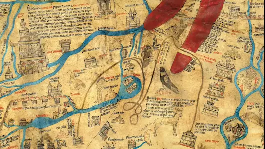
The Gough Map or Bodleian Map is a Late Medieval map of the island of Great Britain. Its precise date of production and authorship are unknown.
There has been no authoritative date for the map's production. Thomas Martin believed it dated from the reign of Edward III, while 19th-century scholarship suggested a date of c. 1300, during the reign of Edward I. More recently, the map was believed to have been made within an eleven-year window, based on historical changes of place names and sizes. The earliest given date is deduced by the depiction of a city wall around Coventry, which was first constructed in 1355. The latter date is usually given as 1366, the year in which the town marked on the map as Sheppey was renamed Queenborough.
Most recent studies, based on handwriting and stylistic evidence, support a later period of production. One study concludes that the map must have been made in the early years of the fifteenth century, while another suggests that the map was produced in the 1370s but extensively revised, perhaps as late as 1430.
It is generally accepted that the map may have been conceived earlier, and that it could have been one of several similar copies. In particular, it has been argued that some of the information on the map reflects the interests of Edward I, dating the prototype to around 1280.
It is named after Richard Gough, who bequeathed the map to the Bodleian Library in 1809. He acquired the map from the estate of the antiquarian Thomas "Honest Tom" Martin in 1774. Numerous copies of it have been made, with an interactive online version created at Queen's University, Belfast. It measures 115 x 56 cm.
http://www.goughmap.org/
http://www.goughmap.org/map/
http://www.bodleian.ox.ac.uk/bodley/about-us/conservation/case-studies/gough-map
http://googlemapsmania.blogspot.ca/2015/04/the-medieval-digital-map.html
https://www.bodleianshop.co.uk/gough-map-facsimile.html
http://www.goughmap.org/
http://www.goughmap.org/map/
http://www.bodleian.ox.ac.uk/bodley/about-us/conservation/case-studies/gough-map
http://googlemapsmania.blogspot.ca/2015/04/the-medieval-digital-map.html
https://www.bodleianshop.co.uk/gough-map-facsimile.html

Mappa Mundi - A Medieval Vision of the World 6:19
https://www.youtube.com/watch?v=JvG-cW6gIcM
Mappa Mundi - A Medieval Vision of the World 15:38